


Angelenos are known for many things. Being obsessed with brunching, art museums, yoga and above all, hiking. Beautiful views, amazing weather, lovely people - what’s not to love? We’re all trying to find new places to go get in touch with nature, and the Los Angeles area has a plethora of swoon-worthy spots.
I’ve teamed up with Daniel from @LAHikes to provide you all with some adventures you’re sure to love, but if you’re looking for more information or places, definitely check out the LAHikes Instagram & Facebook to get in the loop on the latest.
1. Fish Canyon Falls, Asuza
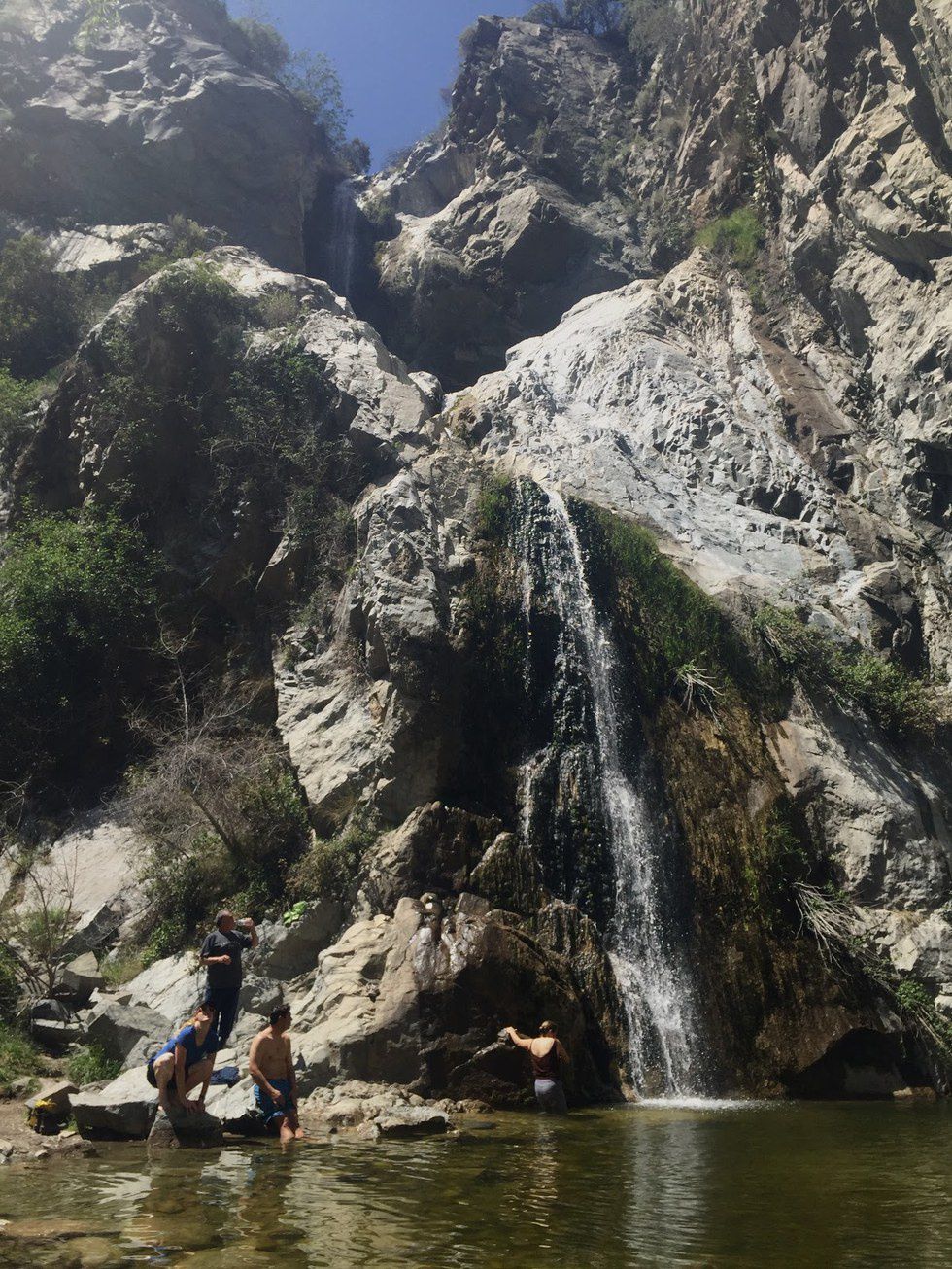
Fish Canyon Falls is a beautiful 80-foot three-tiered waterfall tucked away in Fish Canyon of Azusa, Ca. The path to the falls travels through the underbrush, thickets of trees and finally follows the bends of the canyon to the falls. There’s an incredible amount of beautiful flora along the trail that makes you appreciate nature’s beauty so, so much.
Fish Canyon is also rich with history, once being a settlement for over 200 cabins. But because of a wildfire in 1947 and subsequent flooding in 1948, few structures remain from the destruction. There are also really cool trail information signs along the way about Fish Canyon’s history you can read on the path!
Maps: 3873-3899 Fish Canyon Rd, Duarte, CA 91010
From Encanto Parkway, go all the way through the road until it ends at Vulcan Materials Plant. You’ll see the parking lot right there.
Distance: 5 miles
Elevation gain: 840 ft
Duration: 2.5-3 hours
Difficulty: Moderate
Dogs are allowed on weekends!
Some things to make sure you’re aware of - the opening/closing of the access trail, ticks and poison oak. For the last two, the best way to avoid them would be to just stay on the trail. On the access trail leading to the mountains, there are lots of ‘no trespassing’ signs anyway, and there are tons of signs to keep you on the right path.
2. Jim Morrison Cave, Malibu
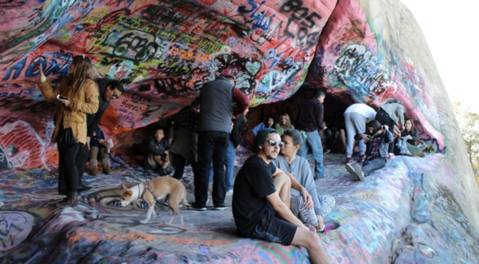
A quick hike in Corral Canyon alongside coastal views will bring you to a cave rumored to be visited by performer Jim Morrison from The Doors. It’s said that Morrison came to this cave for songwriting and inspiration alongside grandiose views. Take the time to visit this iconic and artistic cave in Malibu.
Maps: Mesa Peak Motorway, Agoura Hills, CA 91301
Head west on the Pacific Coast Highway from Santa Monica until you get to Corral Canyon Road, where you will see a 76 gas station. Turn right before the gas station and head up Corral Canyon Road for 5 miles. Corral Canyon Road turns into a dirt parking lot.
Distance: 5 miles
Elevation gain: 840 ft
Duration: 2.5-3 hours
Difficulty: Moderate
LA Hikes actually has some pretty rad photos of this hike.
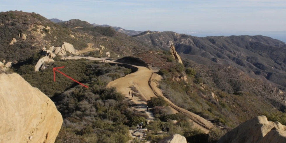
3. Topanga Fire Lookout, Calabasas
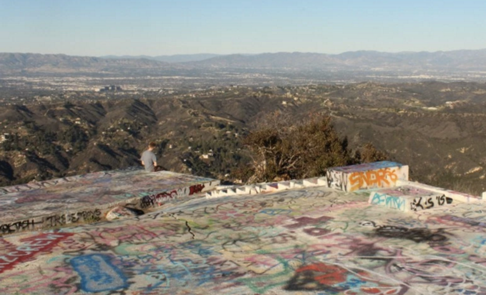
Explore abandoned Topanga Lookout in the Santa Monica Mountains, above Red Rock Canyon Park. This spot has some killer views of DTLA and the Pacific Ocean. Graffiti artists looking to make their own touch have come here to stray paint on the huge concrete blocks that sit on top of the peak.
There are really awesome rock formations along the path, and if you’re into photography, here’s a place to shoot some cool photos.
A short hike, but definitely one that should be on your list if you live in LA!
Maps: 23298 Saddle Peak Rd, Topanga, CA 90290
Parking along dirt road by highway (Saddle Peak Rd)
Distance: 2 miles round trip
Elevation gain: 300ft
Duration: 1 hour
Dog friendly.
4. Bridge To Nowhere
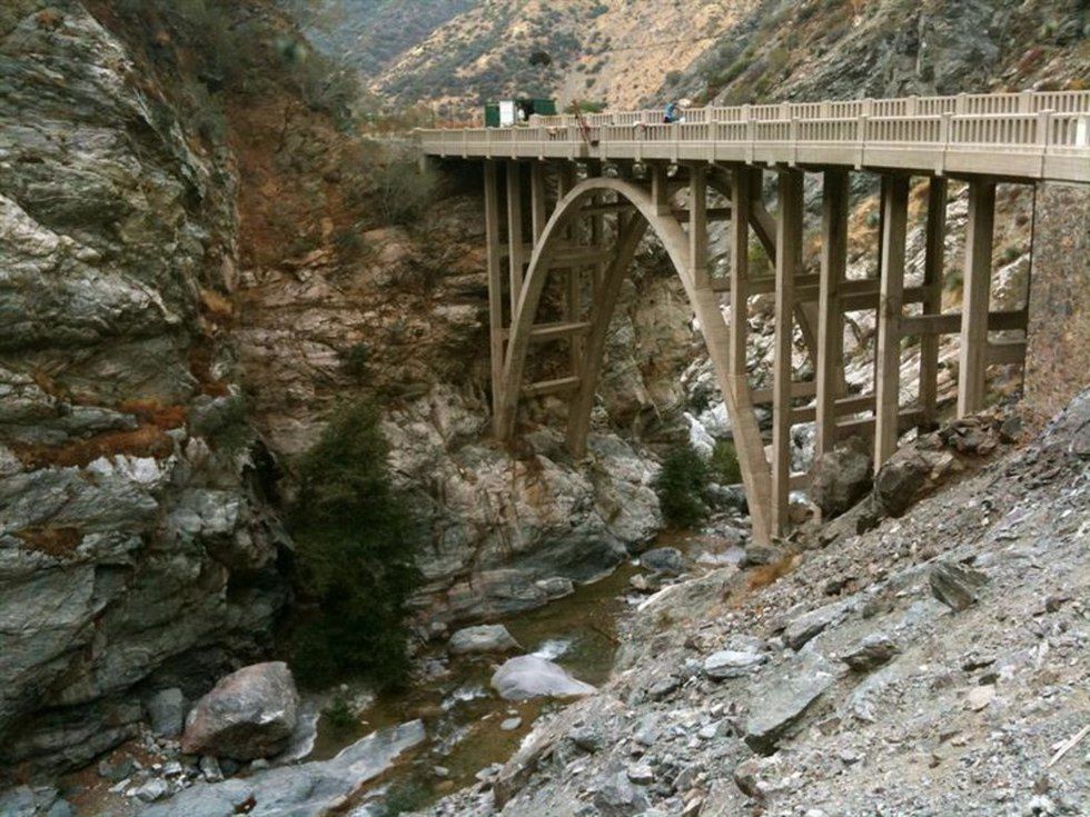
The Bridge To Nowhere is a 120-foot high concrete bridge, literally in the middle of nowhere. It is found on the east fork of the San Gabriel River. All the junctions are pretty clearly marked, and the trail itself is taken care of. The history of this bridge in Azusa is pretty much summed up in its name - the bridge was built in the middle of nowhere starting construction in 1929. It was originally built to connect the San Gabriel Valley with Wrightwood and thought to potentially be one of the most scenic roads in America. But after a heavy storm in 1938 that destroyed everything but the bridge, the county had abandoned its plans to create the highway, leaving this Bridge To Nowhere in the middle of the wilderness.
The bridge is also the only place in California that offers some fun bungee jumping opportunities - but you have to book your time in advance!
This hike isn’t so ‘secret’, but it’s honestly so awesome. You should make a day out of this hike though, if you decide to go on it.
Maps: Camp Bonta Prairie Forks Rd, La Verne, CA 91750
Adventure Pass required ($5 parking permit). You can purchase an Adventure Pass in some stores around Azusa that sell daily & annual passes through the National Forest Services’ website. When on Camp Bonita Road, stay on it until you reach the trailhead.
Distance: 10.1 miles
Elevation gain: 809 ft
Duration: ~7+ hours, depending on how long you decide to stay around the area.
Difficulty: Difficult
Pack a bag full of snacks and lots of drinks! You’re sure to want to take some breaks along the way. I’d advise you to bring some food, too, if you’re going with a group. There’s almost no shade during the warmer months along the trail, so you’ll thank me when you have an abundance of energy fillers in your pack. During the colder months of winter, water levels will increase and some of the crossings might be more difficult to go through (or just more exhausting). If you decide to go during winter, make sure to check out the weather in case of storms too - there could be chances of flash floods that you do not want to run into.
5. Eaton Canyon, Pasadena
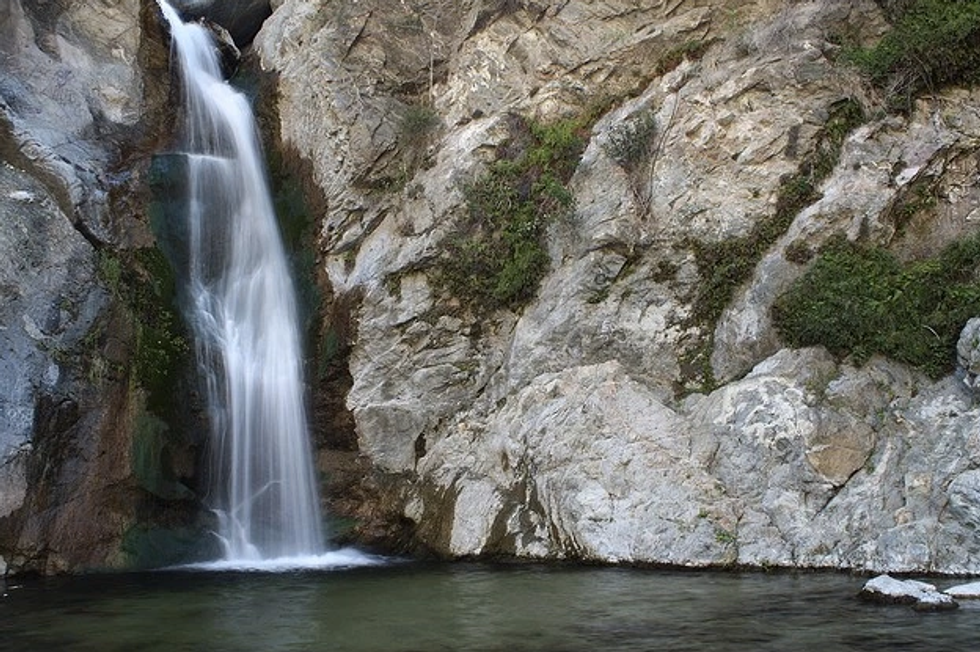
If you love being surrounded by beautiful nature and a 40-foot waterfall, this is for you. Eaton Canyon offers a fun little hike under 4 miles that offers a lot of wildflowers and natural habitats you can see along your trail towards the falls. Most Angelenos really have no excuse not to come to Eaton Canyon - it’s so close to the city. I’ll admit it’s a little crowded sometimes, but if you go in the morning, especially on a weekday, you might not run into the bigger crowds. There’s a small pool at the falls as well, so if it’s hot, it’s quite relaxing.
Maps: 1750 N Altadena Dr, Pasadena, CA 91107
Parking: maps should take you directly there. Around 11am though, the lot can get very full. Make sure to come at an earlier time if you prefer quietness during your hike.
Distance: 3.76 miles
Elevation gain: 592 ft
Duration: 1.5-2 hours, if you want to explore more or stay at the falls
Difficulty: Easy-Moderate
Dog-friendly (but must be on leash).
Stick to the path if you just want to go and enjoy the falls. There’s a warning about another unofficial trail that can lead you beyond the falls and more into the canyon, but anyone who wants to attempt this must be experienced with climbing and canyoneering. It’s really not safe for the average hiker. Many are injured and even killed every year trying to attempt this - I don’t recommend it, but I’d like to give a warning just in case you hear of another path beyond the falls.
6. Millard Falls, San Gabriel Mountains

A short 2-mile hike through a lush trail in Pasadena will bring you to a beautiful and clean 40-foot waterfall. Follow the sounds of the creek and you will find what you are looking for. Wooded and majestic, this trail is breath of fresh air away from LA.
When I came here for the first time, the path was easy to follow, but know that the falls are a steep climb down if you access it from the mountain trail. I missed the trail at first, thinking it was too steep to be a path down, but after asking a couple of other hikers, I realized that was it. Make sure to look for that little path when you hear the falls coming up!
Maps: 4108 Big Tujunga Canyon Road
Park anywhere on the dirt road off the street. There’s also parking further along the dirt road as well.
Distance: 3 miles round trip
Elevation: 150 ft
Duration: 2.5 hours (trail begins on trailhead marker)
Dog-friendly.
7. Cave Of Munits, Woodland Hills
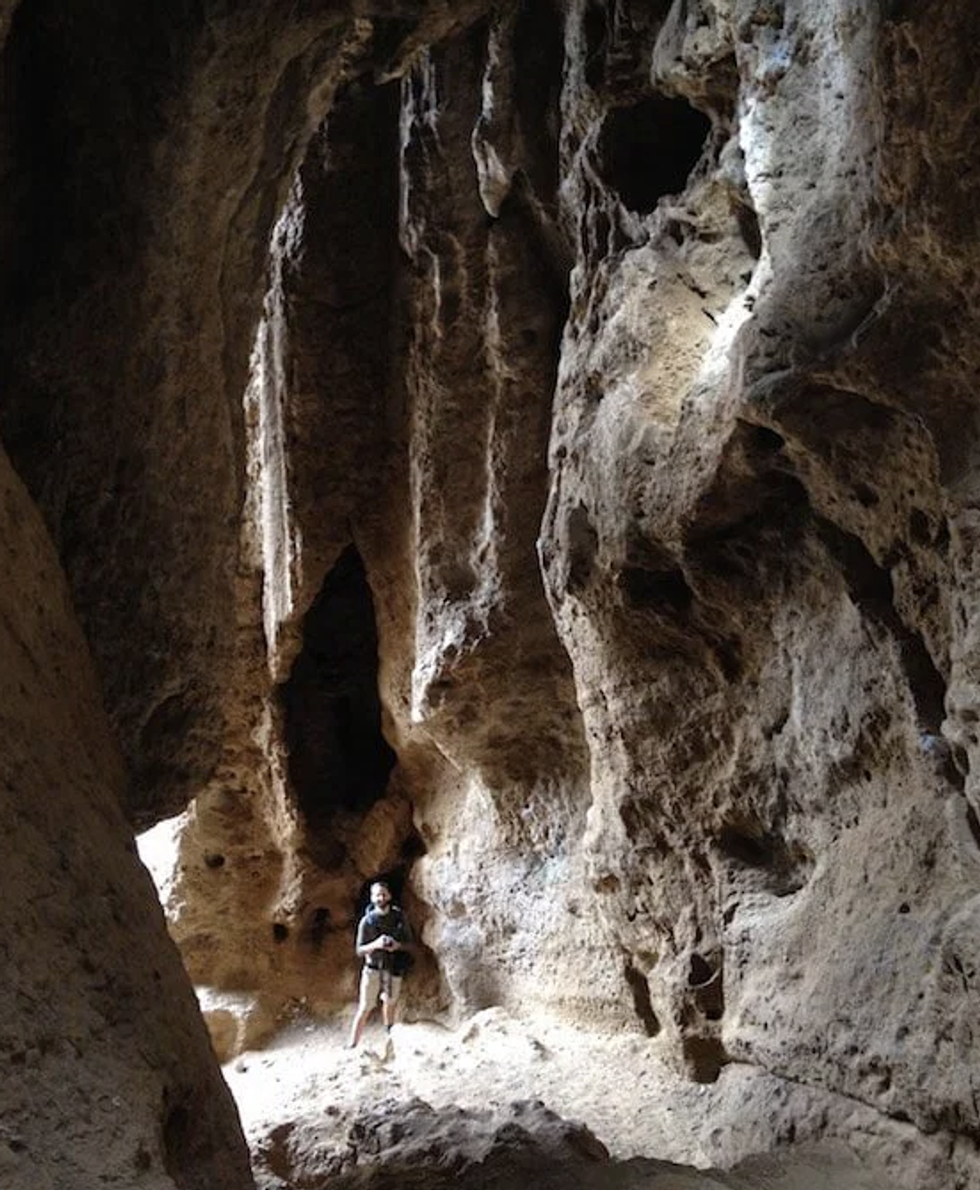
Take a path out of El Escorpion Park in West Hills to do a little spelunking. This 3-mile out and back hike will bring you to a huge chimney cave 50 feet high. Climb into the cave to begin your journey. Legend had it, that it was once occupied by a Chumash Shaman who conducted rituals for the tribe. There’s a lot of really fascinating Native American history within these caves. For more exploration, climb out of the cave and gain a vast view of the San Fernando Valley.
Maps: Victory Blvd, Woodland Hills, CA 91367
Parking is $3, but also includes limited parking outside Victory trailhead
Distance: 2.6 miles
Elevation gain: 722 ft
Duration: 2 hours, depending on how much you want to linger
Difficulty: Moderate
Note: Please, please understand that it’s extremely important to keep places like these clean! We’ve seen it happen to hiking areas like Hermit Falls that have been busy and full of graffiti - and keeping trails a trash-free zone lets nature do its thing.
Also, know that most of these hikes will not have cell phone service, so make sure to screenshot, save, or print your directions of hikes just in case, if it’s your first time.
Again, make sure to follow @LAHikes on Instagram to see amazing photos of new places to hike around the LA area or check out their website to get more information on navigating & more. Have fun!