
Louisiana loses a football field size of land every hour. As this land disappears, so do thousands of square kilometers of natural habitat. Entire communities and their cultures are washed away with the water. South Louisiana is being torn apart by the Gulf; south Louisiana is sinking. The April 20, 2017 issue of the Baton Rouge newspaper, The Advocate, printed a front page article featuring Governor John Bel Edwards’ declaration of land loss as a statewide emergency. Acknowledging this issue in the public eye is hopefully the first step to getting the state of Louisiana to start to care about the disappearing coast. Learning about the rich history of the ground that Louisiana stands on could move more residents into action to save it. Born of the sediment deposited by the mighty Mississippi River, the southern Louisiana deltaic plains continue to sink due to river control structures preventing new sediment deposit, oil and gas transportation canals facilitating saltwater intrusion, and sea level rise threatening to drown the landscape.
The deep history of Louisiana’s sinking land actually begins with the creation of the land. Deltaic land exists in a natural equilibrium of building and sinking. The Mississippi River created the land between Atchafalaya Bay and Barataria Bay with mass amounts of piled up sediment. Those wetlands that form south Louisiana want to shift their equilibrium like any other deltaic wetland. Prior to the arrival of European explorers and settlers, the river could do as it pleased and follow its natural, wandering course. The river meandered and jumped its banks forming many different lobes as the bends of the river have moved. About every 1000-1500 years, the river changed its course to deposit sediment in new areas (Blum and Roberts). The river has formed south Louisiana in six sections or lobes. The first, which once existed in the now Atchafalaya Bay area, has become overcome by the Gulf of Mexico and is starting to build up once more with sediment from the Atchafalaya River at the Wax Lake Delta. The second lobe jumped slightly more eastward, and then the third lobe shifted all of the way east forming the “toe” of the boot shaped state, including much of the New Orleans metropolitan area. The river then flowed back over the flooded second lobe and reformed a forth lobe, then a fifth lobe slightly more to the east, and finally the Bird’s Foot Delta where it has been leveed in ever since settlers began to control the lower Mississippi River (Twilley et al 2016). As the history of deltaic cycles indicates, the river is meant to flood its banks, take a new shape, and most importantly form new land. The last thing a river like the Mississippi, full of upstream sediment, will want to do is maintain a steady course.
While this fact is nothing but beneficial in a purely natural environment, human settlements are not as adaptable to a changing landscape as is the rest of the environment that surrounds the river. Like any other civilization throughout world history, those who settled in Louisiana settled around the river (Twilley et al 2016). It provided transportation, fertile soil, and food. The Mississippi River has long been the lifeblood of the United States trading industry in addition to human development the south. The Coastal Protection and Restoration Authority (CPRA) sites the river as transporting sixty-percent of grain exported from the United States (CPRA 2017). With so much industry and so many lives built around the lower Mississippi, throughout time it became more and more controlled and, subsequently, restricted. No longer able to replenish the sinking land of south Louisiana and the Deltaic cycle interrupted, the river has stopped depositing upriver sediment and creating new land. Land cut off from the river sinks as the spongy mud it consists of compresses farther and farther down and sediment to replenish it lies trapped behind dams and levees. While the separation of land and water attempts to prevent flooding and protect coastal Louisiana from tropical storm surge, it may actually encourage those problems in the end. The issue remains that, in coastal Louisiana, you cannot get land without water; the two cannot thrive apart from one another. Once that separation occurs, an overflow of consequences spill over. The land/water relationship on the Louisiana Gulf coast is a complex, harsh interaction. It cannot be described as constant or sustainable; it is merely a give and take. As humans fight against the natural will of the river in the name of protection, they jeopardize the landscape for future generations and, in some cases, create more problems. With all of the natural flooding that is supposed to occur in the lower Mississippi prevented, the coast loses so many important long term benefits in the place of short term security. One of these most striking losses is that of a sediment to maintain the sinking coast and a barrier against the force of the Gulf.
The capstone example of this paradoxical principle occurred following the April 1927 flood of the Mississippi River as storm surge rose and killed over one thousand people in its wake (Tidwell 31). Following this tragic event, the United States Army Corps of Engineers worked tirelessly to tame the river with levees and control systems. The term “mighty Mississippi” alone provides an idea as to the difficulty of this task. Humans who have settled in the Louisiana deltaic plains are at constant battle with the river, pleading with it to stay put. By damming the river upstream and walling it in further south, the natural process of sediment depositing is halted because the river can no longer jump its banks and flow as it wants to. As a result of dams upriver, fifty percent of the sediment that travels through from the upper Mississippi never makes it even close to the sinking delta (Blum and Roberts). Ever since the Great Flood of 1927, the lower Mississippi River has been pouring out its remaining fifty percent of sediment over the continental shelf into the deep waters of the Gulf of Mexico just to the east of the disappearing wetlands (Houck). That sediment carried out into the Gulf through the Bird’s Foot Delta or trapped upriver, could be used to build up the sinking land between Atchafalaya Bay and Barataria Bay, however it is not for the sake of protection and industry. To allow the river to flow naturally at this point would disturb the major shipping and industrial centers that surround its many crucial ports.
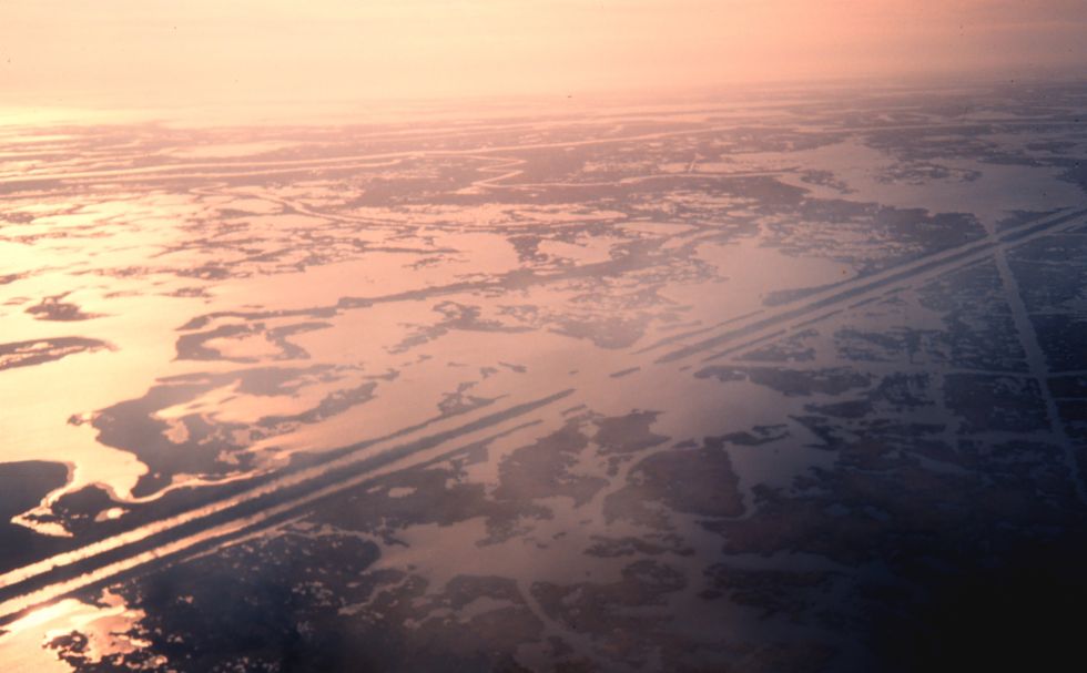
With the advent of major industry on the lower Mississippi, specifically with the discovery of oil in and around Louisiana in the early 1900s, the river has become a working river. In the 1960s and 1970s, oil industry on the Gulf coast experienced a major boom resulting in the cutting up of the marsh to construct navigation and transportation canals (CPRA 2017). While these canals have been vital to the well-being of industry on the coast, they have caused serious repercussions for the health of the wetlands. These channels have allowed salt water from the Gulf to creep into the estuarine and freshwater marsh, a process called salt water intrusion. Although salt water intrusion presents problems for marsh animals, it also has implications for the coastal subsidence and land loss. As salt water makes its way into freshwater marsh, the organisms that thrive in those environments experience increased stress as their environmental conditions begin to change. Many marsh grasses and plants die off and their root systems break down as well. Much of what makes up deltaic soil and holds it together is organic matter. As all of these plants die off and loose root pressure to hold onto soil, the water can easily reclaim the land it surrounds (Houck). This problem of salt water intrusion in conjunction with subsidence leads to a rapidly disappearing coast.
In its current state, the Mississippi River could not deliver enough sediment to encourage a net gain of land along the coast. As stated previously, dams and control structures trap roughly fifty percent of sediment from the river. Even allowed to flow unrestricted, with full sediment load, or through controlled floods, the river would still not be able to overcome sea level rise which threatens to speed up the sinking process. West of the Atchafalaya, in the Chenier Plain, rising sea level poses the biggest threat to wetland loss. However, to the east, river control and intrusion are more prominent concerns with sea level rise looming in the background. As global temperature steadily increases, glacial melt increases filling the world’s oceans with high volumes of water. This increase in volume leads to higher sea level, which has incredibly negative outcomes for cities several feet under sea level and even worse consequences for the rapidly subsiding wetlands (Blum and Roberts). The whole problem, including subsidence, erosion, and sea level rise would be comparable to compressing a very full sponge. At the same time the sponge shrinks in size, the water rises dangerously high as well. Louisiana exists in this dangerous negative sloping land growth curve due to the compounding effects of climate change, erosion, and subsidence coupled with river control.
Significant measures must be taken swiftly if there is any hope of maintaining land between the Atchafalaya Basin and Barataria Bay. World class scientists and specialists have been tackling this issue for a few decades now, and little progress has been made beyond figures on a page. Lack of funding stands in the way of many of the projects that could be done. Aside from that obvious road block, there are so many different groups of people working isolated from one another separated by funding sources or different ideologies. The one thing that does not occur often enough between these groups is the exchange of ideas. Working within the same field and the same problem, everyone has access to the same information, but not the same resources or freedom to use those resources. The Coastal Protection and Restoration Authority (CPRA) operates within the local, state government, but independent research teams scattered across the Louisiana Gulf Coast could have the power to influence change upriver control systems, outside of the state. The United States as a whole needs to take ownership of Louisiana’s grave prognosis. The lack of awareness about coastal Louisiana’s dreary future throughout the nation in itself is a major hurdle to overcome. That nation apathy and lack of knowledge burgeons on the federal end as funding, such as the Louisiana Sea Grant, get continually cut back. Just as the Gulf of Mexico presents its problems for the coast, so to do the avenues to solutions. The give and take relationship the nation has with Louisiana has shifted more heavily toward robbing the coast of sustainability even restoration.
Despite everything pushing back against it, Louisiana has to keep fighting, much like the tireless, raging river that built it. As Gulf pushed in over the years Louisiana surrendered her shores. If there is to be any hope of saving what is left, Louisiana will have to fight long and hard. Recognizing the issue of coastal land loss is the first step in a long journey of even more change in the state. Armed with the history of the region and cognizance of the effects of human action, informed choices for the future of Louisiana can be made.
References:
Blum, Michael D., and Harry H. Roberts. "Drowning of the Mississippi Delta Due to Insufficient Sediment Supply and Global Sea-level rise." Nature Geoscience 2.7 (2009): 488-91. Web. 24 Apr. 2017.
Houck, Oliver. "Can We Save New Orleans?" Tulane Environmental Law Journal 19.1 (2016): 1-68. Web. 26 Apr. 2017.
Louisiana. Coastal Restoration and Protection Authority. “Louisiana’s Comprehensive Master Plan for a Sustainable Coast.” Coastal.louisiana.gov. Baton Rouge: 2017. Web.
Tidwell, Mike. Bayou Farewell: The Rich Life and Tragic Death of Louisiana's Cajun Coast. New York: Vintage, 2010. Print.
Twilley, Robert R., Samuel J. Bentley, Qin Chen, Douglas A. Edmonds, Scott C. Hagen, Nina S.-N. Lam, Clinton S. Willson, Kehui Xu, Dewitt Braud, R. Hampton Peele, and Annabeth Mccall. "Co-evolution of Wetland Landscapes, Flooding, and Human Settlement in the Mississippi River Delta Plain." Sustainability Science 11.4 (2016): 711-31. Web. 24 Apr. 2017.