

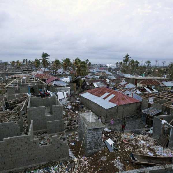

Destruction has reached Florida, Georgia, South Carolina and southern North Carolina in the form of a class three hurricane, nicknamed Matthew. After hitting more tropic countries, such as Haiti and the Bahamas, the eye of the storm is now just a few miles away from Florida's coast. Already there is a extreme warning placed in Florida as winds have already been clocked at over 100 miles per hour. This warning is made after destruction in Haiti from the hurricane left almost three hundred people dead and almost 62,000 people displaced. This is the worst devastation to happen to Haiti since the Earthquake in 2010.
The hurricane is getting worse in Florida and before the full force even hits the state, over half a million homes have lost power and due to the faulty electricity, house fires have occurred. As the eye of the hurricane is now only five miles away from hitting the state, the wind speed and flooding associated with the storm is only expected to worsen. The situation is also expected to worsen in Georgia and South Carolina as the heavy rains are beginning to induce flooding in the areas. The hurricane is also a storm surge to occur, and for those that are not familiar with weather definitions, this means that the sea level is rising due to pressure changes brought on by a massive storm. This storm surge will also contribute to the massive flooding occurring.
This storm is a category three hurricane out of five. This classification system is to help residents in the area know what type of precautions one should take to remain safe. For a category three storm, it is said that major destruction to different buildings will occur and bad flooding inland is also expected to occur. Also there will probably be difficulties in getting electricity and clean water for days after the storm is over, and it is recommended that for residents in this area to be prepared early for this kind of storm with canned food and access to water.
For those in the affected areas, stay safe.